
Nacozari Mining District, Sonora, Mexico (1908)
16 de octubre de 2026
By B. E. Russell
A Region Which Formerly Yielded Gold, Silver and Lead, and Now Promises to Become One of the Chief Copper Camps of the Republic
(1908) – The town of Nacozari is situated at the southern terminus of the Nacozari railroad by which it is connected to the Arizona-Sonora line at Douglas and Agua Prieta, 77 miles distant. The railroad facilities are limited to this road at present, but the grade of the Cananea & Yaqui River or Randolph lines of the Southern Pacific has been opened for about 20 miles south of Nacozari toward the connection with the Guaymas line of the same system. The Nacozari railroad connects at Douglas with the El Paso & Southwestern, which runs from there to Benson, Ariz., and El Paso, Texas; while the Southern Pacific extension from Nacozari will give a seaport terminal on the Pacific ocean at Guaymas, about 200 miles distant.
Nacozari lies about 65 miles southeast of the camp of Cananea. The town lies on the creek of the same name which forms the headwaters of the Moctezuma river flowing into the Yaqui river and thence into the Gulf of California, and comprising the general route followed by the surveys of the Southern Pacific lines. At Nacozari are situated the works of the Moctezuma Copper Company, a public library, a hotel, a store, offices and private residences of that company. The original reduction works consisted of a concentrator which is still in operation, and a smelter that has been idle since the completion of the railroad about four years ago. Since that time the concentrates and first-class ores have been shipped to the Old Dominion and Copper Queen plants in Arizona. The material for the old works, together with the equipment for the five-mile narrow-gage road connecting them with the Pilares mine was shipped into the camp from Naco, Ariz., by freight teams before the completion of the Nacozari railroad.
About a year ago plans for a new concentrator were started, and the mill, a model of reinforced concrete and steel construction, has since been completed. The mill is built in two units of about 750 tons daily capacity each; it is equipped with 72 Johnson vanners, 56 Wilfley tables and 44 iron jigs, built according to special plans prepared by the engineer in charge of construction. The old concentrator has been treating ore at the rate of about 20,000 tons per month, producing about 11,000,000 lb. refined copper annually; this figure can be increased to 35,000,000 lb. by the aid of the new works.
Power for the mine, mill and lighting is generated in Nacozari where the Moctezuma Copper Company has two plants. The old plant is equipped with Crossley producer-gas engines, belt connected with alternating-current electric generators. The new plant is equipped with four 450-h.p. Sterling boilers and three 1000-kw. Curtis General Electric steam turbines direct connected with three-phase alternating-current electric generators, stepping down from 6000 volts at the plant to 230 at the motors. These plants are not connected up, one handling the power and lighting for the town and the mine while the other provides power for the new concentrator.
The narrow-gage railroad connecting the concentrators with the Pilares mine is laid with 85-lb. steel, and ballasted with slag and gravel. The rolling stock consists of two 50-ton Baldwin locomotives and 25- and 30-ton Ingoldsby side-dump reinforced-steel cars.
Early Mining
The earliest known mining in this section was done by the Spanish priests, whose records refer to work being prosecuted as long ago as the year 1600. Since that time it continued in a desultory fashion until the advent of the Americans in recent years. Some of the early writings that have come down to us through church records speak of the fabulous richness of the mines, the most noted of which was the Huacal, in which the bullion was supposed to have been walled up when the Indians made it too warm for the clergy. Humboldt speaks of having come up the Nacozari cañon and of hearing of this mine, but he did not visit it. However much or little truth there was in their accounts, the fact remains that except where water drove out the ancients, the “modernos” have thus far been unable to work successfully properties abandoned long ago. The smelter dumps which I have sampled never yielded more than a few ounces in silver. The arrástra dumps, however, show a higher value; old tailings have been shipped to the smelters with good results. The process used in the arrástras was very much like pan-amalgamation. The ancients do not seem to have used the patio to any extent, if at all. In their adobe smelters they worked the baser ores of silver and lead, but what method they used in parting these two metals is uncertain. The copper ores that have brought the camp into prominence in later years were avoided by the antiguos except when very rich in silver.
The Ore Deposits
For convenience in classification, without any particular reference to geological conditions, the district may be divided into four general belts or mineral-bearing zones. The first and most important is on the line of the Pilares uplift and covers a large territory extending from a short distance east of Nacozari in a general southeast direction for about 10 miles. The second starts at a point about four miles north of Nacozari, near the railroad, and continues for about eight miles to a connection with the first belt. The third follows the general trend of the Nacozari mountains, starting at a point about 10 miles northwest of the town at the foot of the Purica range and continuing south for 10 or 12 miles. The fourth is a more or less isolated belt lying about 15 miles west of Nacozari on which work is being resumed after 20 years of somnolence. In addition, the districts of Tabotacachi and Cumpas may be included, which, while not in the Nacozari district proper, are dependent on the camp for materials and shipping facilities.
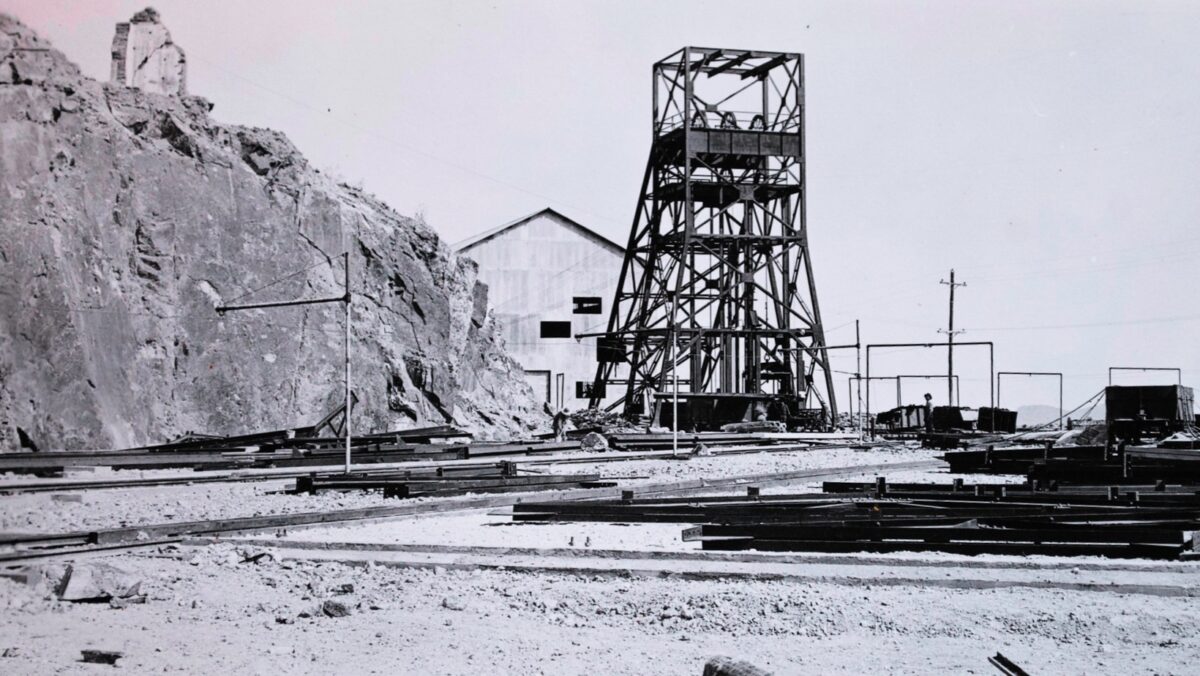
The Pilares uplift, as it is called locally, derives its name from the Pilares mine of the Moctezuma Copper Company which has attained the greatest development of any property in the Nacozari district. This property is opened to a depth of about 700 ft. below the crest of the ridge in which the orebodies apex, or to the 600-ft. level below the collar of the main shaft, besides a surface tunnel and a second shaft from the surface that is now being sunk below the 600-ft. level, the level of the Porvenir tunnel. From the railroad yards at the mouth of the tunnel to the Pilares shaft, a distance of about 5,000 ft., the railroad cars are handled by motors which bring them to the chutes, where they are loaded and then taken back to the mouth of the tunnel to be transferred to the concentrator by the narrow-gage road.
The Pilares orebodies are worked on the “filled stope” method, the only timber used being that needed for chute mouths and shaft sets. The stopes, some of which cover as much as 30,000 sq.ft., are opened for their full extent and then back-stoped. Enough ore is drawn from the stopes to keep the back at a convenient distance for working, and the balance is left to be drawn off when the orebodies above have been worked out. All the men except the mine foremen and timbermen are Mexicans and the work is done on the contract system, the holes being pointed by the foremen and measured up and paid for according to the amount drilled and the character of the ground.
At intervals raises are run through the orebodies and down these the overflow of ore is shoveled to drop to the loading chutes at the tunnel level, or to be transferred to other chutes leading to this level, as the case may be. Under this system the probable cost of the ore per ton at the mouth of the tunnel is about 1.60 pesos.
Origin of the Ore
In an article in the Journal of Dec. 8, 1906, Professor Emmons says in regard to the geological conditions at the Pilares mine:
“The rock forming the groundmass of Paulina hill is a fine-grained andesite very much altered. It forms, in a great part, an eruptive breccia in which the matrix and inclosing fragments are of the same material, and it often shows a distinctly bedded structure. The ore is essentially a breccia of which pyrite, chalcopyrite and quartz constitute the original cementing material, for, although much of the more massive material is impregnated with metallic sulphides, this impregnation has thus far proved commercially negligible. The primary ore minerals are pyrite and chalcopyrite, the products of secondary enrichment being bornite and chalcocite. The whole mass of Pilares mountain between the two shafts (a distance of about 2,200 ft.) is more or less impregnated with ore, although not always of a grade that will pay to work under existing circumstances.”
Professor Emmons accredits the formation of the ore or its zone of greatest enrichment to the presence of two fault planes, one running north and south and the other running east and west, the two intersecting about 30 ft. east of the shaft. In this hypothesis he is borne out, I believe, by Doctor Ricketts.
No development work has been done below the tunnel, but diamond drills have explored the country to a depth of something like 1000 ft. below this level. What the results were are not known except to the company officials, but since the concentrator was started after the diamond drill work had been finished, it is reasonable to suppose that results were satisfactory.
Nacozari Consolidated Properties
The Pilares breccia next shows about a mile to the southeast in the workings of the Nacozari Consolidated Copper Company. This company is driving a cross-cut tunnel to tap at depth the iron gossan showing in three places on the La Galera and Copper King claims. The company’s main working tunnel is now in about 200 ft. and another 50 ft. will tap one of the silver-lead veins that traverse the country in a general east and west direction and lead into the Pilares breccia at the eastern termination. Until a few months ago no work had been done on the properties controlled by the Nacozari Consolidated Copper Company for nearly 20 years; then ore was shipped from the surface workings that carried 10 per cent copper, 20 per cent. lead and 400 oz. silver.
West and southwest of this ground considerable work was done on the narrow stringers of high-grade lead-silver ore by both ancient and modern miners; but nothing of commercial importance has been developed. In this part of the district the best known properties are the San Pedro, the San Pablo, and the Moody. The San Pedro was recently leased by the Moctezuma Copper Company to Messrs. Ish, Camp, Alexander and associates, and ore is being extracted from between the 200- and 300-ft. levels. The San Pablo was worked a number of years ago, the ore being treated by lixiviation, but this did not prove a success and the mine has been closed since that time. The Moody was made the base of a stock company some time ago and work was prosecuted in a desultory fashion for a while, but nothing has been accomplished there. These silver-lead veins gain in size and in percentage of copper as they approach the Pilares uplift, but fall off correspondingly in their silver and lead contents.
The next property on which any work of interest has been done is the Bella Union lying about five miles southeast of the Pilares. This property has been worked only in the oxidized zone and the richer ores have been packed out by leasers.
About two miles to the south of the Bella Union the Los Angeles mine of the Arizona Mining and Trading Company has been developed to a depth of about 100 ft.; but water has proved a disturbing factor, and little of interest can be expected from this place until the mine is equipped to handle the flow. The orebody shows very little on the surface, but what drifting has been done gives promise of opening up a large deposit of ore. In this property the ore is as free from the gangue as the Pilares ore, but unlike that ore it comes in bunches of almost solid pyrite, chalcopyrite, zinc blende and galena, not intermixed to any extent and all carrying good proportions of silver.
To the north of the Bella Union is located the Copper Plate group on which some surface development has been done, and on which the showing strongly resembles that of the Pilares mine. About two miles east of the Copper Plate group the Caridad mine has been partially developed and several thousand tons of copper ore have been blocked out. The great tract of country covered by this Pilares uplift in the monzonite renders more than a mere mention of a few properties an absolute impossibility.
Second Mineral Belt
The second belt consists of a stretch of country about 10 miles long by one mile wide, of which the main mass is andesite of varying ages and accompanied by porphyry and diorite. This andesite is altered to a rock having the appearance of kaolin, in places traversed by seams of quartz and in others heavily impregnated with iron.
Traversing the belt and running with it are numerous dikes of rhyolite of considerable strength and permanence, some of them being continuous on the surface for miles. They are accompanied in places of greatest silicification by lime spar, although this rule is not by any means absolute.
Gold and silver predominate in the ores of this portion of the district, the ores generally occurring in an oxidized state, although where the dikes have attained a structure approximating quartz the ores occur as sulphide. The ores are found in the dikes with no apparent regularity as to the position on the walls or in the ground mass. The dikes themselves, however, never lose their identity as rhyolite, for in their places of greatest enrichment the phenocrysts of alkali feldspar are plainly discernible. In a few gashes and cross-fissures the ores have been concentrated by surface action, and this action is also apparent in the dikes in places, but this does not follow the zones of silicification, it being rather the opposite. The ores in these places carry more gold than silver, and are accompanied by heavy oxide of iron. Such spots of enrichment are analogous to placer deposits, and have never gone to any depth, although productive of considerable ore running into the fancy figures.
At the northwestern extremity of this belt is the Churunibabi mine of the Moctezuma Copper Company.
This property was worked by the antiguos in years past, later by Suits & Riordan, and finally by the Moctezuma Copper Company, for its silicious ores. The property has been opened to the 500-ft. level where a heavy flow of water was struck; since that time work has been confined to the dumps and surface cuts. Development work on the mine has been limited to one of the three lodes traversing it, and in the opinion of those conversant with local conditions, it should still produce ore, probably far in excess of that mined in the past.
The next property of note to the southeast is the San José, now being worked by the San José Reduction Company, of Oakland, Cal.
This property was originally worked by the ancients for the high-grade ore near the surface, and was taken up by Suits & Riordan about 10 years ago. They did considerable development work, opening up a large tonnage of $12 free-milling gold-silver rock, in addition to that extracted by them and treated in the old San Miguel mill. The property was sold to a French company who, after a period of mistakes during which they put a 10-stamp mill on the property, gave up work about seven years ago. The San José company took over the 13 claims, comprising the present property and covering about 180 acres, nearly a year ago. The addition of 15 stamps to the mill together with cyanide tanks to treat the ore crushed is reported to be planned for the immediate future. The orebodies have been opened on the vein for nearly 2,000 ft., and to a depth in places of about 400 feet.
The next property now being worked in this belt on its southeast continuation is the La Mexicana mine, of the Dawson Mining Company.
This property was lately taken over by the company which is now installing a 35-ton Lane slow-speed mill. Heretofore it has been worked by the Mexican owners who treated the ore in arrastras. The development on the property has not as yet attained a point which justifies a permanent reduction plant, but the ore is very evenly disseminated in a rhyolite dike upward of 5 ft. wide for a distance of about 600 ft. A shaft sunk on the vein for a depth of 75 ft. below the original outcrop shows high-grade milling ore carrying gold and silver, with no base metals.
The last property before reaching the Gran Republica fault is the El Globo, where a 1300-ft. crosscut has been run into the hill to get under the surface workings above.
This tunnel has 300 ft. yet to run, which will give it a depth of 1,000 ft. below the outcrop. A gash vein or fissure in the rhyolite produced some ore in the upper workings, and the shaft at that point was sunk to a depth of about 380 ft. The property is equipped with a 15-stamp mill with two Wilfley tables and cyanide tanks. It is connected by a 12-mile wagon road with the town of Nacozari. The mine is situated on a high hill known as the Huacal mountain, the main mass of which is andesite traversed by rhyolite dikes in which the flow lines are plainly discernible.
Third Mineral Belt
The third belt has received very little attention as yet, the work consisting mainly of prospect holes sunk by the owners of the ground. At its north extremity some development has been done in an isolated body of andesite that has produced high-grade galena ores carrying considerable silver; but the formation is very open, and until the permanent zone is reached it will be impossible to say what can be expected. On the contact between the andesite and granite some isolated bunches of silver sulphides have been found that carry as high as 8,000 oz. in silver and 80 oz. in gold, and a tunnel now being run to tap this contact at depth on the Gran Luz claim will be watched with much interest. For some distance to the south of this portion of the belt the formation consists of lime and a granite or syenite that has thus far yielded no permanent mineral, although along the contact the surface is copper-stained in places. Continuing to the south and almost due west of Nacozari, several large denouncements have been made by the Calumet & Arizona Mining Company and others. Work has been confined to surface tunnels and shafts, but nothing of a permanent nature has been done. Diamond drills are now in transit, and work will be instituted shortly with them on the Isabel property of C. N. Lindley. To the south of these properties and on the east slope of old Nacozari mountain the formation changes again to lime and granite; in this belt considerable work has been done from ancient to modern times on the Fortuna mine of the Moctezuma Copper Company. The ore is very base, carrying copper and silver with considerable zinc. The property is now being worked by leasers.
South of this belt some work has been done in the andesite by the Filadelfia Mining Company. The work consists of a tunnel driven in from the level of the Nacozari river on an impregnation of copper and iron sulphides of the andesite. This property covers a lime andesite contact and promises to be of much importance in the future. The Moctezuma Copper Company is also preparing to do some work in this section on a concession that has still two years to run.
The fourth portion of the district which I have mentioned as lying about 15 miles west of Nacozari has no direct connection with the rest of the district. About 20 years ago the district was worked by James Kirk and associates and the ores partly treated there and partly freighted to Benson, Ariz. The district takes its name from the principal mine worked at that time, the Oso Negro. The ores were worked for their silver, and carried also lead, iron and zinc with some silica. These ores did not adapt themselves to the chlorination process installed there, and in the face of the transportation difficulties work was stopped, and the mines allowed to revert to the government. A few months ago the mines were re-denounced by Dr. L. L. Miner and associates of Bisbee and bonded to Sol Camp and associates of Reno and Los Angeles. Work was started on the Oso Negro vein with good results and the prospects of an early resumption of the former activities in that section are very bright. The veins are fissures in the andesite and are continuous to a good depth. They are characterized by step faults, but the ore shoots are continuous on both sides of the fault and they can be easily traced on the surface.
Tabotacachi District
About 25 miles east of Nacozari the Tabotacachi district has shown considerable activity in the past 18 months, but the fall in the price of copper gave this section a setback from which it has not entirely recovered. The Tabotacachi mine has been a steady producer of high-grade ore for the past two years, shipping about one car per month of silver-copper ore to the Douglas smelters. The ore occurs in a fissure in the newer andesites and has been opened to a depth of about 350 ft., from which point the shaft is being driven to the 500-ft. level. The Aliso, Credo Liberal and San Ignacio mines have been shipping carbonate ores from the upper or oxidized zone in which they resemble the Tabotacachi mine. In the Antigua and Texas mines a considerable tonnage of copper-iron sulphides, carrying some silver, has been opened up, but has not been worked since the drop in the price of copper.
With the exception of the Belen mine operations in the Cumpas district are at the present confined to development work. The companies affected by this condition are the Transvaal Copper Mining Company and the Minneapolis Copper Company. The Transvaal company has the largest territory and its plant includes a 100-ton smelter at Cumpas. The Belen Mining Company has continued shipments of silver-copper ore to El Paso, and another class of ore, running high in silver and bismuth, has been forwarded to Swansea, Wales, via Liverpool. A Medbery furnace to treat the low-grade ores has been installed, but the power plant is being rebuilt and until that has been completed the adaptability of the furnace will be uncertain.
The district surrounding the camp of Nacozari is the transition period when modern methods have but recently replaced the “gambusino” work of the early prospector. That there have been “mistakes” here as in all other mining camps is painfully evident, but where work has been done in an intelligent manner the results have been uniformly good. Labor and physical conditions are good, and the two great bugaboos of Mexican mining in the eyes of the average investor, the Yaqui and the law, are absent in the first instance and fair to foreign capital in the second. In addition to the broad campaign of development instituted at the Pilares mine by the Phelps-Dodge interests, that company is prosecuting work on other of its holdings in the district and acquiring new ground; while the field representatives of many other American and foreign companies have given the camp favorable consideration.
Taken all in all, while it is yet too soon to predict the future of the district, the possibilities of the section surrounding Nacozari compare favorably with those of the more developed portions of the Southwest.
Photo: Pilares Mine Shaft, 1920s. Phelps Dodge Collection – Freeport-McMoRan, Inc.
Published on The Engineering and Mining Journal
New York, New York, October 3, 1908
Vol. LXXXVI, No. 14
© All Rights Reserved